Waitākere Ranges hiking guide
Auckland: Waitakere ranges wilderness experience tour from auckland
What is the best trail in the Waitākere Ranges?
Kitekite Falls, near Piha, is the most popular and reliable choice — a well-formed 1.5-hour return walk through native bush to a genuinely impressive multi-tiered waterfall, suitable for most fitness levels.
Auckland’s wilderness, 40 minutes from the CBD
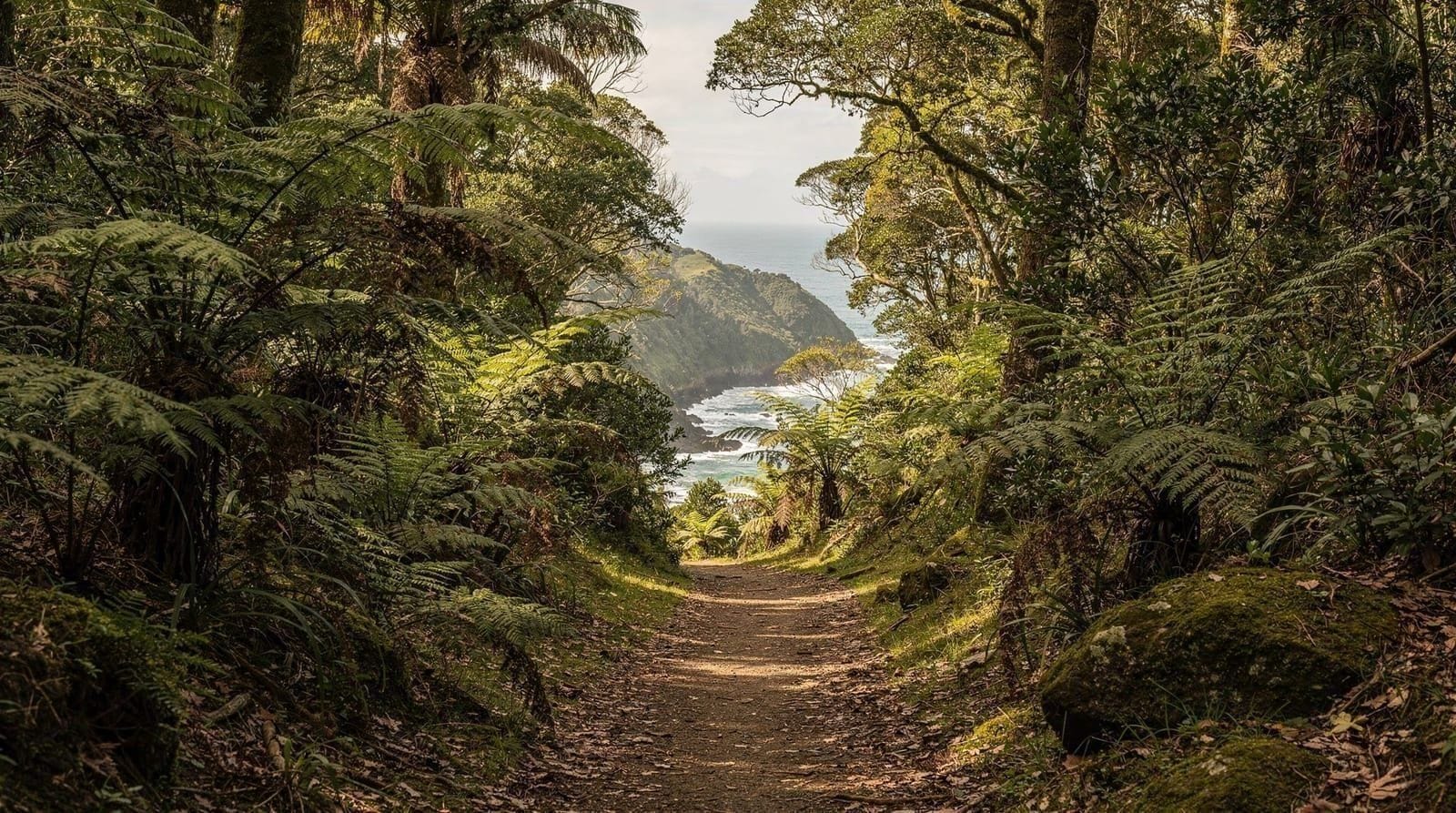
The Waitākere Ranges Regional Park covers roughly 16,000 hectares of native rainforest, black-sand coastline and dramatic ridgelines on Auckland’s western edge — closer to true wilderness than most people expect to find this close to a major city. It’s also where most of Auckland’s genuinely good hiking lives, ranging from a 45-minute waterfall loop to a four-day backcountry trail. This guide breaks the park down trail by trail so you can pick based on your fitness, time, and what you actually want to see.
Start at Arataki Visitor Centre
If you’re driving in via Scenic Drive, the Arataki Visitor Centre is the natural first stop — it has trail maps, current closure information, and a viewing platform with sweeping views over the ranges toward the Manukau Harbour. Given how often tracks rotate in and out of closure for kauri dieback protection (see below), checking here or on the Auckland Council website before you commit to a specific trail will save you a wasted drive to a closed trailhead.
The centre itself is free to enter and staffed by rangers who can advise on current conditions, recent weather impacts (heavy rain can turn a manageable track into a genuinely slippery one for a day or two afterward), and which short loop tracks near the centre are worth doing if you’re pressed for time. It’s also the only realistic place in the park to get a paper map and a reliable toilet stop before heading further in — Piha and the more remote trailheads have minimal facilities of their own. Note that as of recent years the Arataki building itself has had periods of closure for renovation while the grounds and lookout remain open — check ahead if the building’s opening hours specifically matter to your plans.
The drive along Scenic Drive to reach Arataki is worthwhile even without stopping at every lookout — it’s a genuinely pretty road, winding through regenerating native forest with occasional glimpses out over the Manukau Harbour and Waitematā Harbour on either side of the ridge. Allow extra time if you plan to stop at the lookouts, since the road is narrow with limited passing opportunities.
The trails, ranked by effort
Kitekite Falls (near Piha, 1.5 hours return, roughly 1.8km one way, easy): The park’s most popular walk for good reason. A well-formed track through native bush follows Glen Esk Stream to a wide, multi-tiered waterfall with a swimming hole at the base — genuinely rewarding for minimal effort, and the track itself is gentle enough for most fitness levels and reasonably fit kids from around age five up. There’s a small dedicated car park at the trailhead on Glen Esk Road, a couple of minutes’ drive from Piha’s main beach car park, which fills on warm weekends but turns over reasonably quickly since most visitors don’t linger more than the round trip.
Fairy Falls loop (near Piha, 2-3 hours, moderate): Connects two waterfalls via a ridge section with glimpses of the coast. More elevation change and rougher underfoot than Kitekite, but still a well-marked day-walker’s track rather than anything technical. Some visitors combine Fairy Falls with Kitekite Falls in a single longer outing by linking connector tracks, which is worth asking about at Arataki if you want a fuller half-day rather than two separate short walks.
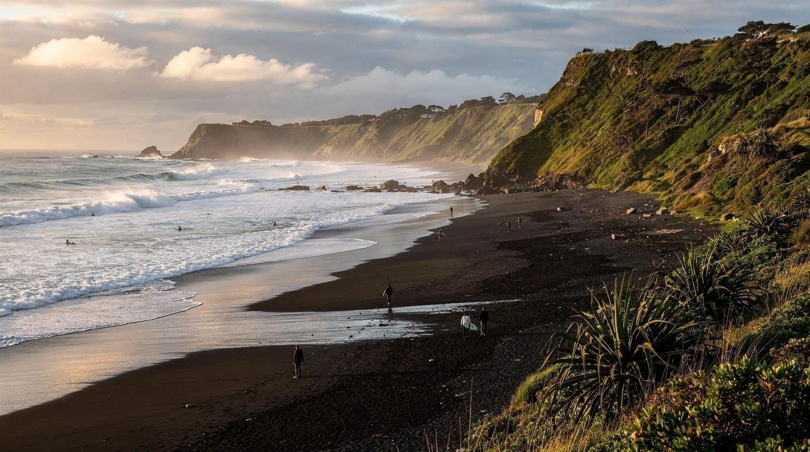
Whatipu coastal walks (southern Waitākere, 1-3 hours depending on route, easy-moderate): Dune systems, old logging tramway relics, and a genuinely remote feel — few visitors make it this far south, which is exactly the appeal if you want the Waitākere experience without the Piha crowds. The access road to Whatipu is longer and more remote than the roads to Piha or Karekare, and there are no shops or facilities at all beyond a basic toilet block, so this suits visitors who’ve already done the more popular tracks and want something quieter, rather than a first-timer’s introduction to the park.
Arataki loop tracks (near the visitor centre, 30 minutes-2 hours depending on loop, easy): Shorter forest walks close to the visitor centre, good if you’re short on time or want a gentler taster of native bush without committing to a full trailhead drive elsewhere in the park. These are also a sensible option if kauri dieback closures have taken out your first-choice track elsewhere in the ranges, since the loops near Arataki tend to stay open more consistently than some of the more remote routes.
Karekare tracks, near the beach of the same name, add a shorter, less-crowded alternative to the Piha-area walks — a mix of short bush loops and a walk to Zion Hill lookout with coastal views, generally quieter than Kitekite simply because Karekare itself draws fewer day visitors than Piha.
The Hillary Trail (75km, 4 days, difficult): Named after Sir Edmund Hillary, this runs the length of the park from Muriwai to the Arataki area, linking together sections of the shorter day tracks into a genuine multi-day tramp. Requires DOC hut or campsite bookings, full wet-weather gear, and self-sufficiency between resupply points — this is a dedicated tramping trip for experienced hikers, not something to attempt as a spontaneous add-on. For those weighing it up, it’s worth comparing to New Zealand’s other Great Walks and multi-day tracks further afield — the Hillary Trail is genuinely tougher underfoot in places than its modest length suggests, given the constant up-and-down of coastal ridgeline terrain, and DOC’s website has the current hut and campsite booking system along with a suggested four-day itinerary breakdown.
Common mistakes hikers make here
The most frequent mistake is not checking track status before driving out — a 40-50 minute drive to find your chosen trailhead closed for kauri dieback protection is a genuinely deflating way to lose half a day, and it happens to visitors who assume an older map or blog post is still accurate. A second common mistake is underestimating how muddy these tracks get; even in a dry spell, sections of Fairy Falls and the Hillary Trail hold moisture under dense canopy, and trail shoes with poor grip turn a moderate walk into a slow, cautious one. A third mistake is treating a Waitākere afternoon as an add-on to a packed day elsewhere in Auckland — the drive alone eats close to two hours round trip, so a rushed visit tends to mean either skipping the walk or racing back for another commitment, neither of which does the park justice.
What a Waitākere day costs
Beyond a rental car or shuttle, the trails themselves are free — no entry fee, no booking required for any of the day walks covered here. A rental car for the day typically runs NZ$70-120 depending on season and vehicle size, and fuel for the round trip from central Auckland adds a modest amount on top. Guided options cost considerably more but remove the logistics: the wilderness experience tour and the private day tours linked in this guide generally run from around NZ$150 to NZ$300+ per person depending on group size and inclusions, which some visitors will happily pay to avoid navigating track closures and winding roads themselves. For context on where a Waitākere day sits within an overall Auckland trip budget, see our Auckland budget guide.
Accessibility
None of the trails covered in this guide are wheelchair accessible — even the shortest Arataki loop tracks involve unpaved forest surfaces with roots and occasional steps. The Arataki Visitor Centre’s lookout platform and grounds are more accessible than any of the actual walking tracks, and represent the most realistic way for visitors with significant mobility limitations to experience the ranges’ scenery without attempting a trail. If accessibility is a firm requirement for your group, a scenic drive along Scenic Drive with stops at the marked lookouts is a reasonable substitute for the walking tracks themselves.
Kauri dieback: why some tracks are closed
Kauri dieback is a soil-borne pathogen, spread partly by soil on footwear, that has killed a significant proportion of Auckland’s kauri trees over the past two decades. In response, Auckland Council has permanently closed some historically popular tracks and temporarily closes others depending on outbreak monitoring. Cleaning stations at trailheads use disinfectant sprays for boots — always use them, both entering and leaving a track, even if it feels like an inconvenience. It’s a genuine conservation measure, not bureaucratic box-ticking, and skipping it risks spreading the disease to trees that could otherwise survive for centuries.
Combining a hike with the beach
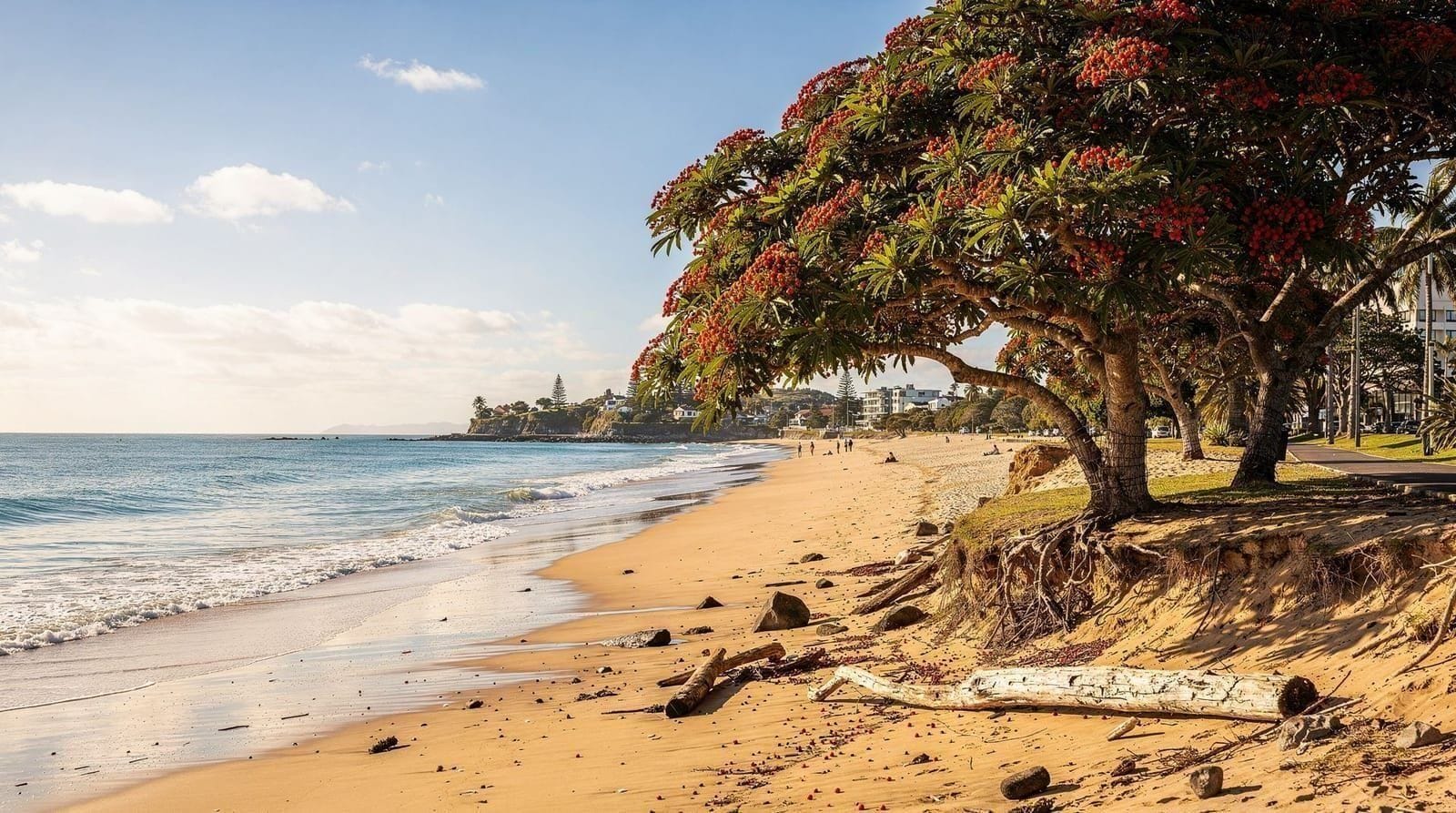
Most of the park’s best day walks sit within a short drive of Piha, which makes it easy to build a half-day that combines Kitekite Falls or the Fairy Falls loop with an afternoon on the beach — though if you’re swimming at Piha itself, stick to the lifeguard-patrolled flags given the rip current risk covered in our Auckland beaches guide. For a fuller west coast itinerary that also covers Muriwai’s gannet colony, see our Piha and Waitākere day trip guide. For a wider comparison of Auckland’s hiking options beyond just the Waitākere Ranges, including the volcanic cone walks in the city itself, see our Auckland hikes overview, and for how the ranges’ cone-shaped neighbour Rangitoto compares as a half-day hike, see our Rangitoto hike guide.
If you’d rather have a local guide handle navigation and explain the area’s ecology and Māori history as you walk, the Waitākere Ranges wilderness experience tour covers a curated route without you needing to track closures yourself. The Piha beach and Arataki Centre private day tour combines a forest walk with beach time, and the west coast discovery tour covers a broader loop through the region if you want to see more than one trailhead in a day.
Getting there
There’s no meaningful public transport to Waitākere trailheads — this is a rental-car or organised-tour region. From central Auckland, allow 40-50 minutes’ drive to Piha via Scenic Drive (itself a worthwhile drive, winding through forest with several lookout points), or slightly less via the more direct route through Titirangi. Roads are narrow and winding in places; drive cautiously, especially in wet weather when the surface can be slick. See our driving in New Zealand guide if you’re not used to left-hand traffic on rural roads, and our car rental Auckland guide for booking advice specific to this kind of day trip.
If you only have a few hours
If your whole Waitākere visit needs to fit into two to three hours including the drive, Kitekite Falls is the only realistic choice — it’s the shortest, most reliable, and least likely to be affected by closures given how well-maintained the track is. If you have a fuller half-day (five to six hours including driving and a stop at Piha beach afterward), add Fairy Falls or extend into a Piha beach stop using our Auckland beaches guide for swimming safety notes. If you have a genuinely free full day and want the quietest experience the park offers, Whatipu rewards the extra driving time with a wilder, near-empty coastline that most day-trippers never see.
Combining with the wider region
Waitākere sits close enough to other west Auckland attractions that a longer day trip can reasonably combine a forest walk with more than just a beach stop — kayaking on the Manukau Harbour is possible for visitors who want to extend a Waitākere day onto the water; see our kayaking Auckland guide for operators covering this side of the city as well as the Hauraki Gulf side. If you’re building a full day trip itinerary around the ranges rather than treating it as an isolated hike, our best day trips from Auckland guide places Waitākere alongside the region’s other options so you can compare it against, say, a day trip to Waiheke Island or further afield.
What to pack
Waitākere trails get muddy year-round regardless of recent rainfall, so proper closed footwear with grip matters — trail runners or hiking boots, not sandals or thin-soled sneakers. Bring water (no refill points on trail), and given New Zealand’s extreme UV exposure, sunscreen even under bush canopy where sun exposure feels lower than it is. A light rain layer is worth carrying even on clear mornings, since coastal weather here shifts quickly.
When to go
Autumn (March-May) and spring (September-November) offer the most reliable trail conditions — drier underfoot without summer’s crowds. Summer (December-February) brings the driest weather overall but also the busiest car parks at Piha and Kitekite Falls, so arrive early. Winter (June-August) is the wettest season, with the muddiest tracks, though the waterfalls run at their fullest and most photogenic if you don’t mind the conditions underfoot.
Breaking it down further: December and January are reliably busy, with Kitekite Falls’ car park often full by mid-morning on fine weekends — arriving before 9am or hiking on a weekday avoids most of the crowd. February frequently brings the driest, most stable trail conditions of the whole year, arguably the best month for the Fairy Falls loop specifically. March through May cools gradually while staying largely dry, and is many locals’ preferred hiking window for exactly that reason. June through August is genuinely wet, with some tracks becoming slippery enough that the extra caution slows your pace noticeably — this is when checking Auckland Council’s closure list matters most, since heavy rain can trigger temporary closures beyond the standard kauri dieback rotation.
September and October see conditions improving but tracks still carrying winter’s moisture in shaded sections. November is a strong all-round choice — drying tracks, lengthening daylight, and crowds not yet at summer peak. If you’re weighing a Waitākere day against other rainy-day options in Auckland more broadly, our Auckland weather by month guide has month-specific rainfall and temperature detail beyond what’s practical to cover here.
Frequently asked questions about hiking the Waitākere Ranges
Why are some Waitākere tracks closed?
Kauri dieback disease, a soil-borne pathogen that kills kauri trees, has forced Auckland Council to permanently or temporarily close sections of track to protect remaining kauri. Closures rotate — always check the Auckland Council website or the Arataki Visitor Centre before you go.
How do I get to the Waitākere Ranges without a car?
Public transport barely reaches the ranges — there’s no direct bus service to most trailheads. A rental car, shuttle, or organised tour is the practical option for almost everyone.
Is the Waitākere Ranges safe to hike alone?
The day walks covered here are generally safe for solo hikers who stick to marked tracks, tell someone their plan, and turn back if weather turns. The terrain is steep and can be muddy and slippery, so proper footwear matters more than usual.
Can you swim at Kitekite Falls?
Yes, there’s a swimming hole at the base of the falls, popular in summer. Water is cold year-round and can rise quickly after rain, so check conditions before swimming.
How long is the Hillary Trail?
75 kilometres across four days, running the length of the Waitākere Ranges. It requires DOC hut or campsite bookings and genuine backcountry preparation — not a casual add-on to a city-based trip.
What’s the best time of year to hike the Waitākere Ranges?
Autumn (March-May) and spring (September-November) offer the driest, most stable trail conditions. Winter (June-August) brings the heaviest rain and muddiest tracks, though the waterfalls run fuller.
Top experiences
Bookable activities with verified prices and instant confirmation on GetYourGuide.