Hiking Rangitoto Island: the complete guide
Auckland: Rangitoto island ferry roundtrip pass
How long does the Rangitoto Island hike take?
The summit track takes about 1 to 1.5 hours each way from the wharf, so budget 2.5-3 hours for the return hike plus extra time if you detour to the lava caves. Combined with the ferry crossing, a half-day trip is realistic.
Auckland’s youngest volcano, and its best half-day hike
Rangitoto Island is the largest and youngest of Auckland’s roughly 50 volcanic cones, formed in a series of eruptions around 600 years ago — young enough that Māori oral history records witnessing the eruption. It sits a short ferry ride from downtown Auckland and offers one of the city’s most distinctive hikes: a walk across raw black lava field and regenerating pōhutukawa forest to a summit with a 360-degree view straight back at the Auckland skyline. It’s also entirely doable as a half-day trip without a car, which makes it one of the easiest “proper” hikes to slot into a city-based itinerary.
Getting there: the ferry
Fullers360 runs regular ferry services from the Downtown Ferry Terminal on Quay Street, a five-minute walk from Britomart, with the crossing taking about 25 minutes. Sailings run more frequently in summer; check the current timetable before planning your day, and book ahead for weekend and peak-season (December-February) sailings, which can sell out. There’s no jetty-side café or shop, so plan your return sailing time before you set off — missing the last ferry back means a very long wait, since there’s no other way off the island. The Rangitoto Island ferry roundtrip pass covers the crossing both ways and is the simplest way to lock in your timing.
Return sailings typically run at set intervals through the day rather than continuously, so build a genuine buffer into your summit walk timing — arriving back at the wharf 15-20 minutes before your booked sailing is a sensible habit, especially since there’s no phone signal in parts of the island to check updated times. Fares generally run in the NZ$45-65 return range per adult depending on the operator, season, and whether you book a standalone ferry pass or a bundled tour that includes commentary. Children typically travel at a reduced fare, and family passes are sometimes available, which is worth checking directly with the ferry operator if you’re travelling as a group.
Some sailings depart via Devonport on the way to or from Rangitoto, which can be a useful way to combine a look at Devonport with the island trip on the same day if your schedule allows, though not every sailing follows this route — check the specific timetable rather than assuming.
The summit track
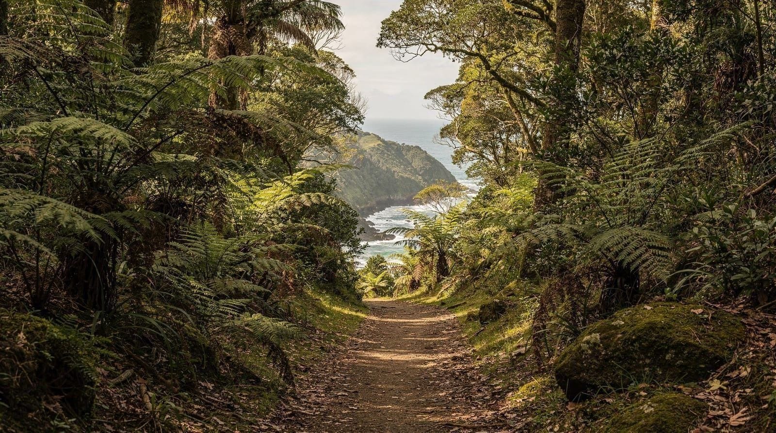
From the wharf, the main summit track climbs steadily through regenerating pōhutukawa forest — the world’s largest pōhutukawa forest, in fact, having grown entirely out of bare lava rock since the last eruption — before opening onto exposed lava field for the final push to the summit. Budget 1 to 1.5 hours each way; the track is well-formed with boardwalk sections over the roughest lava, but it’s a genuine uphill walk on uneven ground, not a stroll, so wear proper shoes rather than sandals.
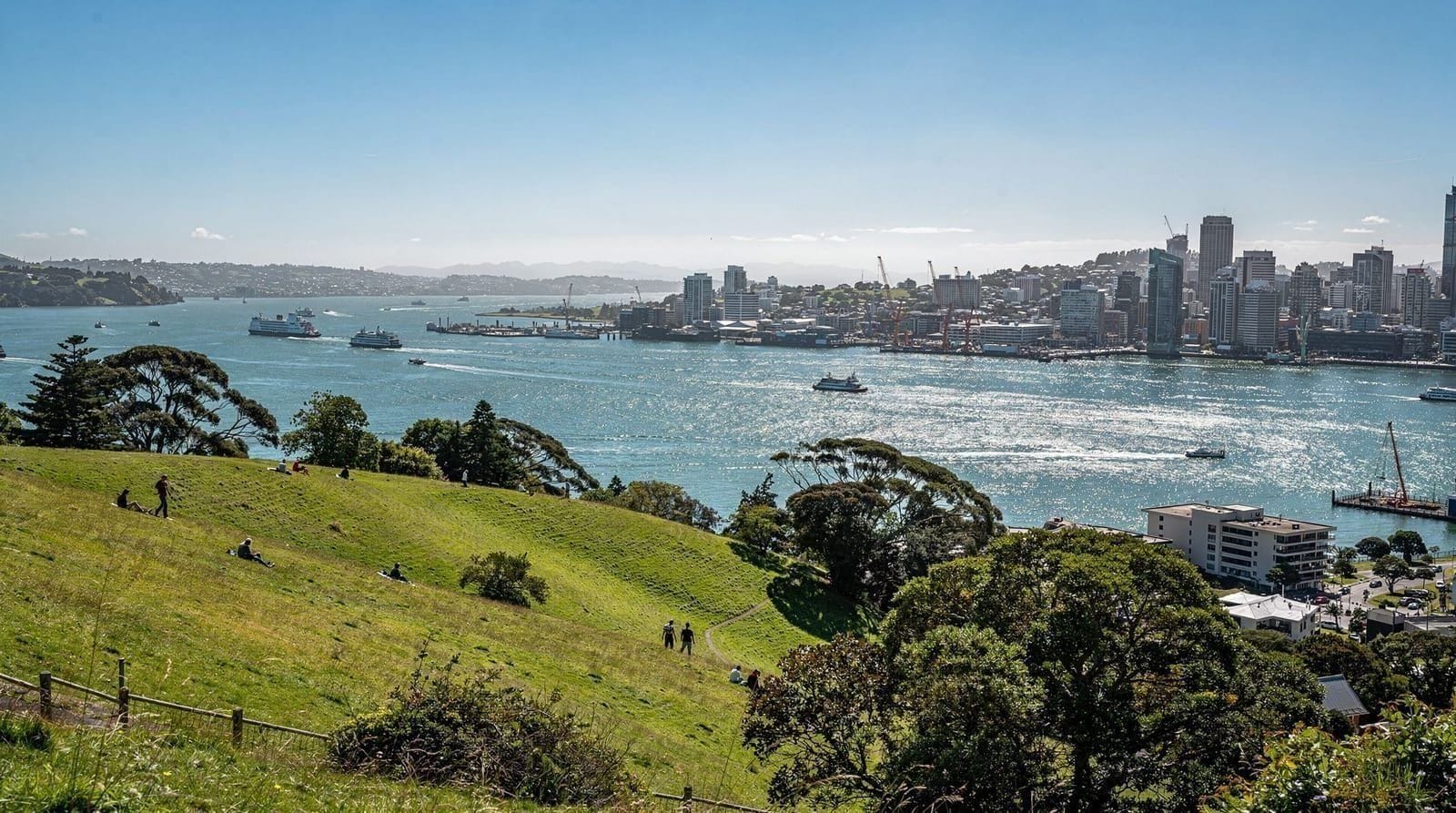
The summit itself sits at 260 metres and delivers a reward disproportionate to the effort: a full panorama across the Hauraki Gulf, back toward the Auckland CBD and Sky Tower, and out toward Waiheke and the wider gulf islands on a clear day. There’s a viewing platform and information panels on the volcanic history and Māori significance of the maunga (mountain).
The track itself is a genuine physical undertaking despite its short length by tramping standards — the surface underfoot shifts between packed gravel, boardwalk over sharp lava, and looser scoria sections near the top, and the near-total lack of shade on the upper half means the exertion feels greater on a hot day than the distance alone would suggest. Most visitors in reasonable fitness manage the full return trip comfortably within the 2.5-3 hour estimate, but if you’re travelling with young children, older relatives, or anyone with joint issues, budget extra time and expect to need rest stops. There are a couple of benches along the route, but nowhere to refill water, so what you carry up is what you have until you’re back down.
Māori oral history holds a genuinely rare distinction here: Rangitoto’s eruption, dated to roughly 600 years ago through a combination of geological and archaeological evidence, is thought to be witnessed and recorded in the oral traditions of local iwi — making it one of very few volcanic eruptions anywhere in the world with a documented human eyewitness account passed down through generations rather than reconstructed purely from geology. Footprints preserved in ash on nearby Motutapu Island, Rangitoto’s older neighbour connected by a causeway, are physical evidence of people fleeing the eruption in real time. The name Rangitoto itself is generally understood as a shortened form of a longer traditional name referencing “the bloody sky,” a description consistent with witnessing an active eruption.
The lava caves detour
A signposted side track off the main route leads to a network of lava tube caves — hollow tunnels formed as the surface of a lava flow cooled and hardened while molten rock kept moving beneath it. You can walk into the more accessible caves with a torch (bring your own; there’s no lighting), adding roughly 30-45 minutes if you want to include this detour. It’s a genuinely interesting stop if you have the time, and one of the few chances most visitors get to walk inside a volcanic feature rather than just look at one. The caves are cool and often damp inside even on a hot day, and the footing is uneven volcanic rock, so sturdy shoes matter here as much as on the main track. If your group includes anyone uneasy in enclosed, dark spaces, note that some sections require crouching and the torch is genuinely necessary — natural light doesn’t reach far past the entrance.
What to bring
There’s nothing on the island — no shops, cafés, water fountains or shade shelters beyond the forest canopy on the lower track. Bring all your own water (more than you think you’ll need, since much of the upper track is exposed to sun with minimal shade), sunscreen (New Zealand’s UV levels are extreme, and the open lava field offers essentially no protection), sturdy closed shoes, and a hat. A packed lunch is worth carrying if you’re planning a longer visit combining the summit and the caves.
If you only have half a day
Rangitoto is naturally a half-day trip once you factor in the ferry, so this is less about trimming the hike itself and more about timing. Taking the earliest reasonable morning sailing gives you the most flexibility — cooler temperatures for the climb, a quieter track before other ferries arrive, and enough of a buffer that a slower-than-expected pace doesn’t put your return sailing at risk. If your schedule genuinely only allows two to three hours total including the ferry crossing, it’s tight but doable if you skip the lava caves detour and keep the summit visit brief; our Rangitoto half-day guide covers this trimmed-down version in more detail, including which sailings work best for a short visit. Trying to combine Rangitoto with another major activity on the same day — say, a full Waitākere Ranges visit — is possible in theory but rushed in practice, given how much of the day the ferry timing alone consumes.
Should you hike or kayak-and-hike?
The standard ferry-plus-summit-walk trip suits most visitors and needs no particular fitness or paddling experience. But if you want a genuinely memorable variation, the full-day kayak and hike to Rangitoto summit has you paddling across the Waitematā Harbour to the island before doing the same summit walk — a proper full-day adventure that combines two Auckland highlights in one trip, and doesn’t require prior kayaking experience since it’s guided. For something different again, the sunset and night sea kayak tour to Rangitoto skips the daytime summit hike in favour of paddling out as the sun sets, a completely different (and quieter) way to experience the island. If you’d prefer a guided tour that includes commentary on the geology and history without any paddling or independent navigation, the Rangitoto explorer tour is worth comparing.
Honestly weighing the options: the standard ferry-and-hike is the right call for most first-time visitors, since it’s cheaper, requires no special skill, and still delivers the island’s best feature — the summit view. The kayak-and-hike is worth the extra cost and effort specifically if you want a genuinely memorable, story-worthy day rather than just a good one, and you’re reasonably fit. The sunset kayak is the pick for repeat visitors or anyone who’s already done the daytime hike and wants a different angle on the island. Skip the kayak options entirely if anyone in your group is a nervous or non-swimmer, since even guided sea kayaking carries more inherent risk than a walking track.
Common mistakes on the Rangitoto hike
The single most common mistake is arriving without enough water, on the assumption that a 260-metre hike “can’t be that serious” — the exposed lava field and lack of shade make dehydration a genuine risk on a hot, still day, and there is nowhere on the island to buy or refill water. A second mistake is cutting the return timing too fine against the ferry schedule; the walk down takes nearly as long as the walk up given the uneven surface, and rushing the descent on loose scoria is how ankle injuries happen. A third mistake, more about expectations than safety, is assuming Rangitoto has a “beach day” component — the coastline is mostly sharp volcanic rock rather than sand, so this is a hiking and viewpoint trip, not a swimming trip, despite the ferry crossing feeling similar to a beach day logistically.
What the trip costs
Budget NZ$45-65 per adult for a standalone return ferry ticket, with children usually discounted. The kayak-and-hike and sunset kayak tours run considerably higher, generally in the NZ$180-280 per person range depending on operator and season, reflecting the guiding, equipment, and longer duration involved. Beyond the ferry or tour fare, the trip costs nothing else — no entry fee to the island itself, no charge for the lava caves detour, and nothing to buy once you’re there (which cuts both ways, since you also can’t buy anything you’ve forgotten). For how this fits into an overall daily budget, see our Auckland budget guide.
Accessibility
The summit track’s uneven lava and boardwalk surface, combined with genuine elevation gain, makes it unsuitable for wheelchairs and challenging for visitors with significant mobility limitations. The area immediately around the wharf is flatter and more manageable for a shorter, easier outing if the full summit isn’t realistic for your group — you’ll still get a sense of the lava field and pōhutukawa forest without committing to the full 1-1.5 hour climb. There’s no accessible transport on the island itself (no shuttle, no vehicle hire), so any exploration beyond the immediate wharf area happens on foot.
How it fits into your Auckland trip
Rangitoto pairs naturally with a broader look at Auckland’s volcanic field — see our volcanic cones of Auckland guide for how Mount Eden and One Tree Hill compare, and our general Auckland hikes guide for how the island fits alongside Waitākere Ranges trails. If you only have a few hours rather than a full half-day, our Rangitoto half-day guide covers a trimmed-down version of the trip. For island background and other things to do beyond the hike, see the Rangitoto Island destination guide. If you’re comparing Rangitoto to Auckland’s other volcanic-cone hikes as part of a wider plan, our best day trips from Auckland guide places it alongside the region’s other options, and if you’re building a first multi-day itinerary, our 3 days Auckland and Auckland first-timer 4 day itineraries both slot Rangitoto in as a half-day.
Month by month
Rangitoto is walkable year-round, but conditions shift meaningfully by season given how exposed the summit track is. December through February is warmest and driest, which makes for the best views but also the toughest physical conditions on the shadeless upper track — an early morning sailing is worth prioritising to beat both the heat and the crowds. March to May cools while generally staying dry, arguably the most comfortable window for the actual climb. June to August is coolest and wettest; the lava rock gets slippery when damp, so extra caution and grippy footwear matter more this time of year, though the crowds thin out considerably and ferries are easier to book last-minute. September to November sees improving weather and lengthening days, a solid shoulder-season choice.
Whatever month you’re travelling, cross-check our Auckland weather by month guide, and note that some winter sailings run less frequently than the summer timetable, so double-check availability before planning your day around a specific departure time.
Practical notes
Rangitoto has no permanent residents and, by regulation, no dogs are permitted (to protect the regenerating native bush and birdlife). Mobile phone reception is patchy in places, so let someone know your return ferry time before you set off. The island is a scientific reserve, so stick to formed tracks — the volcanic rock underfoot is sharp and the vegetation regrowing on bare lava is fragile. Rubbish bins are limited to the wharf area, so plan to carry out anything you bring in rather than expecting bins along the track itself — a small point, but one that matters for keeping a genuinely wild, protected landscape the way it is.
Frequently asked questions about hiking Rangitoto Island
How long does the Rangitoto Island hike take?
The summit track takes about 1 to 1.5 hours each way from the wharf, so budget 2.5-3 hours for the return hike plus extra time if you detour to the lava caves. Combined with the ferry crossing, a half-day trip is realistic.
Do I need to book the Rangitoto ferry in advance?
Booking ahead is recommended in summer (December-February) and on weekends year-round, since sailings can sell out. Off-peak weekday sailings usually have room to buy on the day.
Is the Rangitoto summit hike difficult?
It’s moderate rather than easy — you’re walking uphill on uneven volcanic rock and boardwalk for over an hour, with minimal shade. Reasonably fit adults and older children manage it comfortably; very young children may need to be carried for parts.
Is there shade on Rangitoto?
Limited. The lower forest sections have some canopy cover, but much of the upper track crosses open lava field with little shade — sun protection is essential.
Can you swim at Rangitoto?
There’s a small swimming area near the wharf, but most visitors come for the hike rather than the beach — Rangitoto’s coastline is mostly rocky rather than sandy.
What are the lava caves on Rangitoto?
A network of lava tube caves formed as the volcano’s surface cooled around still-flowing lava beneath. A signposted side track off the main summit route leads to accessible caves you can walk into with a torch.
Is there food or water available on Rangitoto?
No — there are no shops, cafés or water fountains on the island. Bring everything you need, including all your drinking water, before boarding the ferry.
Top experiences
Bookable activities with verified prices and instant confirmation on GetYourGuide.